Note the concrete boundary marker ahead of you.
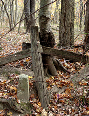
The concrete marker, about 50 feet off the trail in front of the post, is part of the remains of an old fence corner. There used to be strands of barbed wire that ran on either side of the boundary marker along an old fence line. Old photographs indicate that this area was once pastured.
At your feet you may notice, depending on the time of year, that the ground is particularly wet here. Previous UMBC student research shows that this section of the trail has a very high water table surface. This means water that is underground is very close to the surface. At this location the water underground is moving toward the Herbert Run tributary to the north.